
1. The Princeton and District Museum and Archives.
167 Vermilion Avenue, Princeton
https://princetonbcmuseum.com/
250-295-7588
The Princeton and District Museum and Archives has a wide range of historic collections reflecting Princeton's history: an extensive range of local pioneer items providing a visual record of life in Princeton; a First Peoples basket display exhibiting various weaving styles and periods; a fossil and mineral collection of over 40,000 specimens many from local sites; Princeton newspaper collections from 1900 through to the present (1900-1953 and 1998-2016 digitized and online); approximately 4,000 photographs from 1880 to present chronicling area history; recordings featuring pre-1980 interviews with Princeton pioneers; historic maps and mining reports from 1858 to present and original records of all mining claims in the area. Of significant value: a collection of 83 Notman Studios glass plate photographs (late 1800-early 1900s), and a 1880's cabin that housed John Fall Allison's daughter Lily, her husband John Norman and their six children. There is a small gift shop and public washrooms. Please call or check the website for up-to-date information on hours of operation. Other web sites of interest are http://princetonmuseum.org and http://highway3museumtour.info
2. Castle Rock
Off Highway 3
https://princetonbcmuseum.com/
250-295-7588
Castle Rock is 2.6 kilometres east of Princeton on Highway 3. It is on the opposite side of the river, but clearly visible from the highway. This rock is on the land of the Allison family, the first European settlers in Princeton. John Fall Allison arrived in Vermilion Forks (now Princeton) in 1860 where he staked gold, copper and coal claims. He died in 1897 and asked to be buried close to the landmark Castle Rock.
3. The Hedley Heritage Museum.
712 Daly Avenue, Hedley
250-292-8787
The Hedley Heritage Museum offers historic mining displays, a 1904 cabin and barn, a heritage park with mining artifacts and picnic tables, a superb black and white photo collection, family history research, volunteer guides, a spotting scope for viewing the Mascot Mine, tea room and gift shop, plus gold panning and tourist information. On open days, enter the Lyon family's house, a replica of the mine manager's residence. The backroom replicates a hospital facility of the era. Across the street you can view relics of old-time mining machines and ring the fire bell. The Mascot Mine is visible from the Hedley Museum.
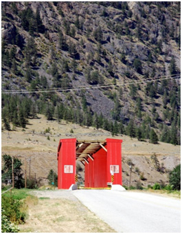 4. The Ashnola Bridge
70 Ashnola Road, Keremeos
The Red Bridge is the sole survivor of five bridges that crossed the Similkameen River on the Great Northern Railway line from Oroville, Washington, to Keremeos. Abandoned in 1954, in 1961 the one-lane, covered bridge was turned into road access to the south side of the Similkameen River and to the Ashnola Valley. It creates the gateway to Cathedral Provincial Park and the Ashnola recreation area. Built by the Vancouver, Victoria & Eastern Railway in 1909, the red bridge is one of the most photographed sites in the Similkameen Valley. It's also the last remaining covered bridge in Western Canada and remains an important link to our mining and railroad heritage. Canada Post included it in the Historic Covered Bridges stamps issued in 2019.
5. South Similkameen Museum.
414 9th Avenue, Keremeos
(250) 499-6075
The "new to us" building was the former Masonic Lodge that originated in Hedley. The larger exhibition space in the newly renovated premises has enabled the museum staff to properly display the huge collection of local historical artifacts they have gathered over the years. New technology enables visitors to search not only the photo archives but also the collections from other small museums all over British Columbia. From cattle rustling to the growth of the fruit industry, heritage is commemorated through the artifacts and documents that make up the collections at the Keremeos Museum.
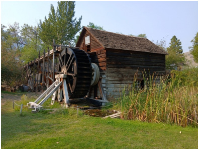 6. Keremeos Grist Mill
& Gardens at Keremeos.
6. Keremeos Grist Mill
& Gardens at Keremeos.
2691 Upper Bench Road, Keremeos
250-499-2888
In 1872, Barrington Price (1841-1913), an English gentleman from an upper-class family, moved to the Similkameen Valley to take over the Hudson Bay Company's ranch land and trading post. Success soon followed. By 1877 Price opened a store and water-powered mill to turn locally grown wheat (grist) into flour. Together, the mill and store served the needs of the local settlers, First Nations and miners travelling on the historic Dewdney Trail. Unfortunately, within a decade, Mr. Price's business started to decline due to changes in transportation in British Columbia. In 1885, the completion of the Canadian railroad through valleys far to the north caused the horse trails through the Similkameen to become unimportant trade routes. The mill ceased to work and the property was purchased by J. H. Coulthard as a home for his family. Price returned to England in 1904. The construction of the grist mill encouraged First Nations and the settlers living in the Similkameen to grow wheat and for the first time, the full agricultural potential of the soil was realized.
Services include a gift shop, café and public washrooms as well as tours. Camping is also available: campground consists of 11 creekside RV/tent/camper sites with power and water hookups.
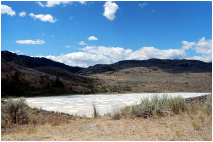 7. Lake Khiluk (Spotted
Lake).
7. Lake Khiluk (Spotted
Lake).
Highway 3 Osoyoos
GPS 49.07898, -119.56146
https://syilx.org/about-us/syilx-nation/spotted-lake-2/
Spotted Lake is an unusual saline lake located on Highway 3 in the Richter Pass about eight km west of the intersection at Highways 3 and 97 in Osoyoos. It is sacred to Okanagan First Nations, caretakers of the site. There are dense deposits of minerals that appear once the spring rainwater evaporates. Magnesium sulphate crystallizes in summer and other minerals harden to reveal the rings. Spotted Lake can be viewed from the side of the highway at a small pullover area. Permission is required from the Okanagan First Nations to enter the site.
8. The Nk'mip Desert Cultural Centre
1000 Rancher Creek Road, Osoyoos
250-495-7901
The Nk'Mip Desert Centre is a 9,000 square-foot interpretive centre that exhibits two films, the Inkameep Day School Art Collection, indoor and outdoor interactive exhibits, a 1.5 km walking trail, and reconstructed traditional Okanagan village, and (visitor favourite) interpreter hosted programs that boast a fun-filled experience for all ages! The centre is also an architectural marvel, and was built from local, sustainable materials. From the parking lot you will see the spectacular rammed-earth building that showcases interpretive exhibits inside: films, the Nk'Mip Day School Art collection, artifacts, rattlesnake awareness programs, gift shop and washrooms for visitors. Outside exhibits include information about the unique ecology and a reproduction of a traditional kekuli (pit house).
9. Osoyoos and District Museum and Archives.
8702 Main Street, Osoyoos
250-495-2582
Established in 1963, the museum has recently moved to its new location at 8702 Main Street across from the Town Hall. Its purpose is to collect artifacts, photographs, textual records and to preserve, interpret, provide access to, and educate the public about our local history. Admission is by donation. They have public washrooms and a small gift shop.
10. The Art Gallery Osoyoos.
8713 Main Street Osoyoos
https://osoyoosartscouncil.com/the-art-gallery-osoyoos
250-495-2800
The gallery offers original works produced primarily by local artists and artisans. It was established in 1988, and is supported by a volunteer committee, gallery manager and wonderful group of dedicated volunteer hosts.
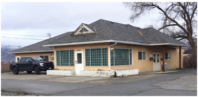 11. The Osoyoos Customs
House
11. The Osoyoos Customs
House
609 Highway 97, Osooyoos
The Colonial Customs House was in use between 1930 and 1952. It is located at 609 Highway 97 at the Canadian side of the border. When the new customs house opened in 1952, this building served as brokerage house for many years. Today, the front enclosure and side extensions were added but the small front peak and retention of the basic footprint help reflect its vintage character.
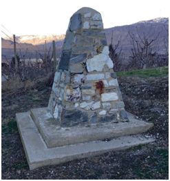 12.Customs House Cairn
176 Avenue East off Hwy 97
GPS 49.06342, -119.51832
The Customs House Cairn marks the location of the first Customs House. The Osoyoos Customs House was built in between 1901 and 1902. It remained in Osoyoos until 1930 when a new customs house was built at the Canada-US border. Both the Osoyoos customs house and the border customs house had corrals beside them to hold livestock prior to inspection by a veterinarian. In Osoyoos, the veterinarian lived across the street from the customs house while the customs officer lived in the customs house itself.
13. Osoyoos Canal Walkway.
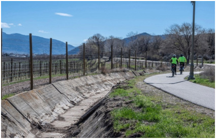 GPS 49.02440, -119.48016
From Highway 97 turn onto 62nd Avenue and park at the top of 115 Street. A kiosk marks the entrance of the paved walk/ bike trail beside the historic remnant of the irrigation canal that transformed the valley from the arid shrub-steppe grassland that leads to Highway 3. There is a longer route you may choose that goes downhill, through a tunnel under the Highway 3 and onto a loop around the airport. In 1919 BC Premier John Oliver initiated the South Okanagan Irrigation Lands Project to create employment for returning First World War veterans. Twenty-two thousand acres of land were purchased, divided into 5-10-acre plots, and sold to veterans at a reasonable cost. The canal was completed from Vaseux Lake to the Canada-US border in 1927. It is the life-giving water that has transformed the rare semi-arid shrub steppe brush grasslands into the rich agrarian orchards and vineyards that we enjoy today.
14. The Osoyoos Desert Centre.
14580 146 Avenue, Osoyoos
https://destinationosoyoos.com/listing/osoyoos-desert-centre
250-495-2470
There's a small pocket of semi-arid shrub steppe land in the South Okanagan that is locally known as the "Pocket Desert." We have a rare ecology that is unique in Canada. This habitat is home to many endangered species, some of which exist nowhere else in Canada and others that exist nowhere else in the world. The Osoyoos Desert Centre is an outdoor interpretive centre where visitors may learn about our rich biodiversity, the importance of conserving our endangered ecosystem and habitat restoration. You can also learn about the history of land development in the area. The centre has public washrooms and a small gift shop.
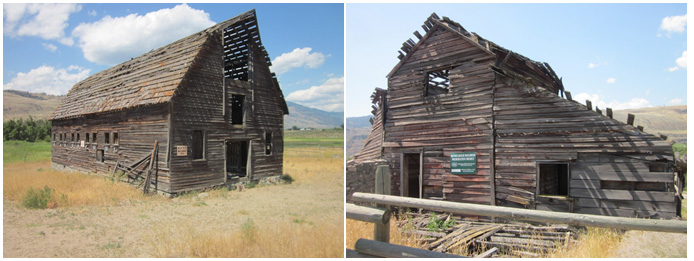 15. Historic Haynes
Ranch.
15. Historic Haynes
Ranch.
Road 22 and Black Sage Road, Oliver
GPS 49.09148, -119.53051
This land has been occupied by the Syilx people for thousands of years. However, these old buildings are associated with the Haynes family, who have been ranching in the South Okanagan since the late 1860s. These structures reflect part of our local history. They have been left in their natural state and are slowly deteriorating. This location is probably one of the most photographed locations in the South Okanagan. Valentine (Val) Haynes, a very well-respected rancher used this as his winter home for many years. He is a member of the B.C. Cowboy Hall of Fame. The Haynes family vacated this home in 1963. The adjacent old barn was likely built shortly after an older barn/stable was destroyed by fire in 1915. The fire was visible from as far away as Oroville in the United States. It was reported at the time that: "Six fine horses including a splendid Shire stallion Kongs Charter, were burned to death. Six sets of harnesses and several saddles were destroyed as well as a quantity of grain."
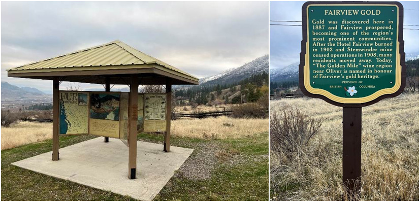 16. Fairview Townsite.
Fairview Road, Oliver
GPS 49.17458, -119.59999
https://www.oliverheritage.ca/history-of-fairview
Located on the south side of Fairview Rd., 4.3 km west of the junction of Highway 97 and Fairview Rd. This site has a kiosk with large historically themed murals and a 900 km walking trail through part of the old Fairview Townsite area. It is a pleasant walk in an arid grassland ecosystem, with great views. Unfortunately, only subtle evidence of the once bustling community remains.
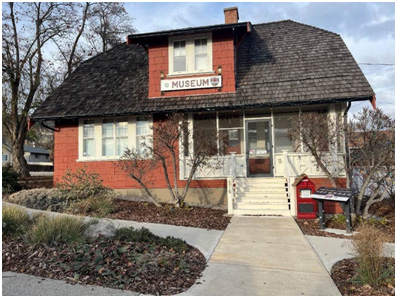 17. Oliver and District
Museum.
17. Oliver and District
Museum.
474 School Road, Oliver
250-689-6655
This small, professionally managed, community museum is located in a historic B.C. Provincial Police station. It was constructed in 1924 with an official opening in 1925. The old Fairview jail has been relocated to this site and there is also a heritage garden and a small gift shop. Explore the wheelchair-accessible heritage garden, which features native plants and information about flora, animals, the landscape and their names in nsyilxcən or the Okanagan language.
 18. The Ditch Trail.
S.W. corner of Similkameen Avenue and Fairview Road, Oliver
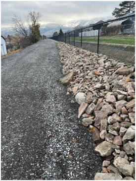
The attraction is located in the Town of Oliver. The trail begins and ends adjacent to the bridge located on the southwest corner of Similkameen Avenue and Fairview Road. This is a 970 km, round-trip walk, along the primary irrigation canal, and is associated with the Southern Okanagan Land Project. The construction of this irrigation system led to the development of the Town of Oliver. There is an interpretative sign at the south end of the Trail. The terrain is gentle and the view to the south, down the Okanagan Valley, is very nice. Video on the Ditch: https://youtu.be/RdtHyfDHqDA
19. Bassett House.
1145 Main Street, Okanagan Falls
https://okanaganfallsheritage.org
250-497-7047
The Bassett House is a prefabricated structure built in the early 1900s. It was purchased by the Dick Bassett family and shipped in pieces by rail from Winnipeg to Okanagan Landing and then by paddle-wheeler down the lake to Penticton and, finally, by horse and wagon to Okanagan Falls, which is the oldest planned community in the South Okanagan. The house was purchased by the Okanagan Falls Women's Institute in 1982 and donated to the Heritage Society in 1983 to restore and maintain.
20. Okanagan Falls Heritage and Museum Society.
1145 Main Street, Okanagan Falls
https://okanaganfallsheritage.org
250-497-7047
The main feature on the property is the Bassett House which, arrived in Okanagan Falls in 1909. The Basset House and the museum are open for guided tours throughout the summer. Kenny McLean Trophy Room: A log building on the grounds of the OK Falls Heritage and Museum Society was dedicated in 1993 to displaying the many awards, belt buckles and other rodeo gear belonging to Kenny. It is open to the public four days a week, year-round, during the business hours of the Thrift Shoppe. He is also commemorated with a statue across the highway in Centennial Park.
21. Okanagan Falls United Church.
Corner of Willow Street and 11th Avenue, Okanagan Falls
250 497-1171
This is the building with the history of the "Blasted Church." The vestibule and sanctuary are part of the original church that began its life as a Presbyterian Church in the mining community of Fairview around 1897. During the decline of Fairview, the building fell into disuse, remaining empty for a number of years. The congregation in Okanagan Falls and their minister decided in 1929 to dismantle the church in Fairview and bring it to their community in Okanagan Falls. The practice in those days when a building was to be dismantled, was to board over the windows and seal the doors of a building in which a stick of dynamite was suspended. The force of the dynamite loosened all the nails so that removal of the boards was accomplished more easily and with less damage to the wood. Unfortunately, the iron cross atop the steeple was broken. The material was then transported 16 miles to Okanagan Falls and was reassembled on its present site. The church was reopened with a dedication service on January 19, 1930.
22. Hotel Kaleden.
2nd Street and Ponderosa Avenue, Kaleden
https://www.kaledencommunity.com/hotel
The Hotel Kaleden was built in 1910 as one of the cornerstone buildings of the Town of Kaleden, designed as one of the leading buildings in the interior of B.C. It was one of the first buildings to feature electric light, running water, private sleeping porches and exclusive dining rooms. Hotel Kaleden opened its doors in 1912, offering luxurious stays with scenic views. It featured 26 beds and two restaurants. It has a special place in the community's heart. It has garnered recognition at the provincial, national and international levels as a heritage site deserving preservation.
Kaleden's primary public park is south of Hotel Kaleden (201 Ponderosa Avenue, Kaleden). Its amenities include a sandy public beach and park along the water with picnic area and washrooms. Food service is available at Jane's Farmhouse Takeout Restaurant, and Linden Gardens Frog City Café.
23. Kaleden Museum and Archives.
320 Lakehill Road, Kaleden
https://www.kaledencommunity.com/museum
250 488 5043
Contact: Mike Gane at 250-488-5043. By appointment only.
24. Penticton's Front Street Heritage Neighbourhood (original business district).
12 Front Street, Penticton
Colourful Front Street, originally known as Smith Street (for S.C. Smith a well-known Vernon businessman and a shareholder in the South Okanagan Land Company who had a lumber yard at the north end of the street) is within walking distance of Shanghai Alley, Penticton's Chinatown and the 100 and 200 blocks of Main Street, home to many of Penticton's earliest commercial buildings. East of Front Street is the oldest house in Penticton, Ellis Street Cottage, at 127 Ellis Street.
25. Penticton Museum and Archives.
785 Main Street, Penticton
https://www.penticton.ca/our-community/arts-culture/museum-archives
250-490-2451
As you enter the museum, you are welcome to immerse yourself in the history and culture of Penticton and the South Okanagan through fascinating exhibits and interactive learning spaces with tons of hands-on displays and activities for the whole family. On permanent display at the museum is the exhibit "Penticton: The Shaping of Place" which invites you to step back in time and explore the forces that shaped Penticton through its history. As you walk through the exhibit you will journey through a series of landscapes that stand as milestones in the development of the area. The Bill Pickerill Military Gallery features permanent exhibits about local military history, with a special focus on local involvement in the First and Second World Wars. The gallery is named in honour of Bill Pickerill, a long-time RCMP officer and Second World War veteran who was a dedicated volunteer at the Penticton Museum for two decades.
The Archives We have hundreds of thousands of records, photos, documents, media sources, maps and newspapers that can provide information about your property, genealogical records, or answer a question about Penticton's past. Online Bus/Driving Tour Follow the Penticton BC Transit Bus Routes. Local heritage sites with brief descriptions. https://www.art-bc.com/places/penticton/museums-heritage-sites/penticton-museum-archives/
26. KVR/CPR Station and The Cannery.
216 Hastings Street and 1475 Fairview Road, Penticton
https://www.penticton.ca/business-building/community-planning-land-use/heritage-registry/kvr-station
The Kettle Valley Railway Station is a two-storey 1941 structure with a steeply pitched, chalet-style roof and two gabled bays at each end, the easterly one having been added in 1945. It includes a single-storey warehouse added in 1965. Its Tudor-style architecture, known as "Hunt Club," is unique in western CPR stations. OneSky, a tenant in the building for over 20 years, is the current owner and operator of the historic railway property, and uses the space to run and expand their community programs and services. The Cannery, formerly Aylmer Cannery, is a large industrial complex that comprises four conjoined buildings: a wood-frame former warehouse at the westerly end built in either 1936 or 1942; a large concrete former processing plant at the easterly end built in 1948; a connecting concrete block former storage building built later in 1948 and a rear concrete block warehouse built in 1968. It was an employer of a large number of men and women; it reflects labour practices and social conditions over several decades. The Cannery Trade Centre has over 30 businesses including a theatre, restaurants, a brewery, a bakery and other retail outlets.
 27. S.S. Sicamous
Marine Heritage Park.
27. S.S. Sicamous
Marine Heritage Park.
1099 Lakeshore Drive, West, Penticton
250-492-0403
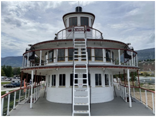
The S.S. Sicamous Marine Heritage Society works to protect, preserve and promote the marine heritage of the Okanagan Valley. Our society was founded to preserve the sternwheeler S.S. Sicamous and prevent it from slated closure. Later the society began acquiring other vessels and structures that were in danger of disappearing. Today the society works to preserve and communicate this unique chapter in Okanagan and Canadian history. In the park CN Tug #6 was the last tugboat to operate on Okanagan Lake, and its retirement in 1973 marked the end of an era in the valley. The dredge shed is a large timber storage building located in the park. It was built in 1933 and was once located at the mouth of the Okanagan River. The S.S. Okanagan stern saloon is the last surviving structure from a sister ship of the S.S. Sicamous. The S.S. Naramata is the last surviving freshwater steamboat in Canada.
28. Naramata Heritage Museum.
214 Robinson Avenue, Naramata
250-496-5709
A museum for Naramata was always a dream of Lorna Rounds and her life partner, Phil Rounds (affectionately known as Mr. & Mrs. Naramata). They collected artifacts and archival material for years. A lot of it was stored in their basement and in the old Centennial Hall (now the Naramata Library). Their dream really came true when the museum moved into the old Naramata Fire Hall in 1999. A beautiful mural was painted on the west wall by Josh Wood and Tim Skrypiczajko. In a place of honour is our community quilt (Centennial Quilt). Lorna instigated the creation of the quilt which is made from many squares stitched by interested ladies of the community. These depict Naramata scenes. We enjoy tremendous community support and invite you to share in our history. We also have a small gift shop for souvenirs of your visit.
29. Naramata Inn.
3625 1st Street, Naramata
778-514-5444
The Naramata Hotel, now the Naramata Inn, was built as a Mission-style mansion in 1908 by the town's founder, John Moore Robinson and it has been a private home, a hotel, a girls' school and now a boutique hotel. Originally called Nine Mile Point, reflecting the fact that the land the village sits on forms a point into the lake and is nine miles from Penticton, Robinson first renamed it East Summerland, after the other town that he had founded and named Summerland. The hotel was described as "a modern hotel of beautiful architecture and with all the conveniences of an up-to-date tourist resort," and the most magnificent flower garden surrounding any hotel in the interior." Washrooms: Washrooms are located at Manitou Beach, an eight-minute walk away.
30. Kettle Valley Railway and Adra Tunnel.
Several entrance points
From Penticton: A 40-minute drive (33 km) or a 2-hour bike ride covers the distance to the Adra Tunnel. From Myra Canyon: Whether you choose to bike or drive, it's a journey of about 48 km, taking approximately 2 hours and 20 minutes by bike. From Glenfir Parking Lot: A quick 10-minute drive (8 km) or a 40-minute bike ride brings you to the tunnel's entrance. From Chute Lake: A scenic 16 km bike route, taking around 1 hour and 10 minutes, leads to the historic site. A GPS self-guided bike tour, starting on the Naramata Bench is available at: https://voicemap.me/tour/naramata/steam-and-stone-bike-the-kvr-to-the-adra-tunnel.
31. KVR Adra Tunnel.
KVR trail, just above Naramata
The Adra Tunnel is an engineering feat from 109 years ago, it preserves the vision, labour, and ingenuity of past generations. It is located along the KVR trail just above Naramata and runs about 490 metres long. The horseshoe-shaped tunnel was originally excavated in 1914 as part of the development of the Kettle Valley Railway. Rail operations stopped in the 1970s while the rail bed was bought by the provincial government in 1990. The public is able to walk or bike through the piece of history. Local architects have designed the recreational site outside of the tunnel. There are information signs in the area, washrooms, picnic tables and an area to park. There is a tour, starting on the Naramata Bench: https://voicemap.me/tour/naramata/steam-and-stone-bike-the-kvr-to-the-adra-tunnel.
32. Rock Oven Park.
Smethhurst Road, Naramata
https://www.rdos.bc.ca/community-services/parks-trails/rock-ovens-park and https://www.trailforks.com/poi/4637/
Rock Oven Regional Park is a collection of stone and rock ovens built between 1911 and 1915 located on the Kettle Valley Rail Trail (KVR). The park is a collection of hiking trails leading to 10+ rock ovens that were built by the immigrant workers while building the Kettle Valley Railway. The rock ovens served as ovens to bake bread and feed the workers. Geared toward the hiker or biker. No road access.
 33. Summerland's
Ornamental Gardens.
33. Summerland's
Ornamental Gardens.
4200 Highway 97, Summerland
250-494-6385
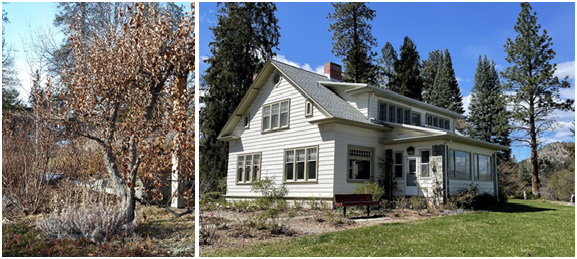
Summerland's Ornamental Gardens are located at 4200 Highway 97, directly across the highway from Sun-Oka Provincial Beach. The Research Station was founded in 1914 to demonstrate successful ways of farming and gardening in the dry Okanagan climate. Two years later, the Ornamental Gardens were established. The gardens contain unique plants. For the historians, the gardens feature Father Pandosy's apple tree. In 1862, Pandosy planted a row of apple trees at the Oblate Mission in Kelowna. Dr. Donald Fisher acquired a scion from one the Pandosy's trees and planted the tree in the garden. Unfortunately, a severe frost killed all of the apple trees in Kelowna, but the one at the farm in Summerland survived. A historic house, the Superintendent's Residence, sits at the top of the hill. It was used from 1926 to the 1960s to house the superintendents and their families. Currently, it is used as an office and workplace. A beautiful place for a walk or a picnic. There are public washrooms. Admission to the gardens is by donation.
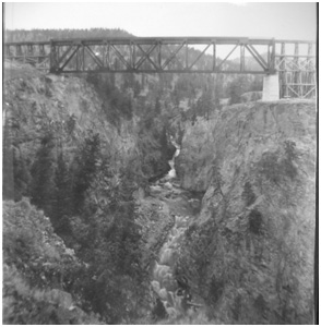 34. Trout Creek Trestle.
Summerland
The over-one hundred-year-old bridge was the highest structure of its kind on the Kettle Valley Railway at the time it was constructed. The KVR was built between 1910 and 1915 and it started covering valleys and mountains between Hope and Midway and connected the Okanagan to the major railroad networks. The trestle bridge was designed by Andrew McCulloch and thought of as a major engineering achievement. The bridge was built between 1912-13 to span the canyon through which Trout Creek runs. Stretching 619 feet across and 238 feet above the canyon floor, the bridge was also the third largest of its kind in North America at the time it was built. The trestle can be seen closely by taking a ride on the Kettle Valley Steam Railway or by taking a walk in the Summerland Ornamental Gardens. Another way to see and walk on the bridge is from the Summerland Sweets facility, located at 6206 Canyon View Road. Summerland Sweets was founded by research station scientist Ted Atkinson in 1962. It features numerous jams and jellies and unique fruit wine. Not far from the facility's parking lot is the KVR Bridge. One can walk across the complete structure; well worth visiting.
 35. Okanagan Fur
Brigade Trail - nqəlxʷa̓qs.
35. Okanagan Fur
Brigade Trail - nqəlxʷa̓qs.
Garnett Valley Road, Summerland
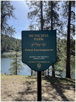
Summerland's Fur Brigade Trail is a provincial heritage site. It is the most scenic section of the Brigade Trail. It offers a spectacular view of Okanagan Lake, at the bend in the lake, overlooking Peachland. The trail has been carbon dated at between 6,000 and 7,000 years old. Getting to the Brigade Trail is weather related. The road is not paved; there are large potholes and it can be very muddy. One begins the journey by travelling on Garnett Valley Road (paved) north. Pavement ends and it is a rough ride to the historic site of Priest Encampment. This site has picnic tables and pit toilets. One continues the journey along a rough dirt road, always taking a right turn at road junctions. The preferred route from there is to park at the natural gas valve station and walk the remaining 0.9 km to the brigade lookout. The surface is uneven; good hiking shoes are recommended.
36. Sir Edward Clouston Orchard Home. Private home, please view from the street.
8617 Victoria Road South, Summerland
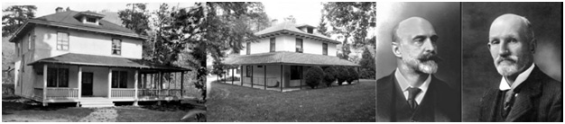
Sir Edward Clouston had a mansion in downtown Montreal, and an orchard home in Summerland. Clouston was knighted for his contributions to banking. He was the general manager of the Bank of Montreal from 1890-1911. He played a central role in the creation of the Canadian Bank Act. Clouston was also noted for his contributions to sport. He played in the first official hockey game in Montreal on March 3, 1875. He was also the first trustee of the Allen Cup. The Clouston home is located on 8617 Victoria Road South. It was built in 1907.
37. Mary Spencer Home. Private home, please view from the street.
13822 Rumball Avenue, Summerland
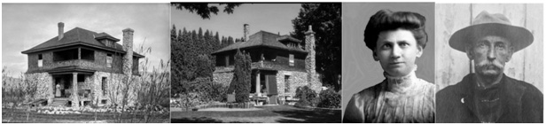
Mary Spencer is British Columbia's most famous female photographer. In 1906, notorious train robber Billy Miner robbed a train near Kamloops. After an extensive manhunt, Miner was captured and faced trial. Mary Spencer was a newspaper reporter and was in the courtroom, covering the trial. She took famous photographs of Billy Miner. Mary had a photography studio in Kamloops. In 1909, Mary and her sister Isabelle moved to Summerland mostly because of the growing Baptist community. For the most part, Mary gave up photography and focused on painting and pottery. The Mary Spencer home is located at 13822 Rumball Avenue. The home remains unchanged. In fact, the living room still contains Mary's furniture.
38. George Barclay Ranch House. Private home, please view from the street.
12409 Victoria Road
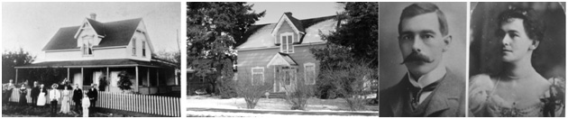
The Barclay Ranch House was built in 1887-1888 by David Lloyd Jones. It was originally located on Jones Flat Road. George Barclay bought the Lloyd Jones property and home in 1892. Barclay moved the home to 12409 Victoria Road prior to his wedding in 1897. The back of the Barclay home has an older structure and probably is the original home of Alexander McLennan and William Conkle, Summerland's first pioneers. Lord Shaughnessy bought the large Barclay ranch in 1902, including the house. In 1903, James Ritchie acquired the property and lived there for many years. The Barclay Ranch House is considered Summerland's most important heritage building.
39. R.B. Angus Orchard Home. Private home, please view from the street.
11777 Dodwell Avenue, Summerland
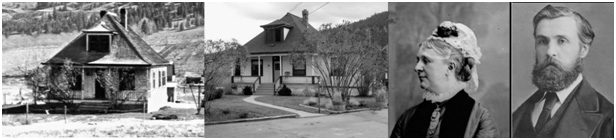
Only two people in Canadian history were knighted twice for their contributions to Canada; and Angus is one. He was offered the knighthood for his contributions to the railway and also for his contributions to banking. He was the co-founder of the Canadian Pacific Railway and president of the Bank of Montreal. Angus had a large mansion in the centre of Montreal and had an orchard home in Summerland. This home is a CPR pre-fab home that was transported by barge down Okanagan Lake and assembled. The Angus orchard home is identical to Lord Shaughnessy's Summerland orchard home. The Angus orchard home is located in Prairie Valley in a section named Millionaires Row. The address is 11777 Dodwell Avenue. The adjoining property to the south was owned by Sir Herbert Holt, president of the Royal Bank, and the adjoining property to the west was owned by Sir Edmund Osler, president of the Dominion Bank (TD Bank later). Angus frequently visited Summerland and used the home when he went hunting. He kept the home until his death and his nephew Roy Angus inherited it. Roy became Summerland's public works superintendent.
40. Major Hutton Home. Private home, please view from the street.
112405 Reynolds Avenue, Summerland
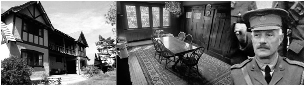
Major E.E. Hutton home is Summerland's favourite heritage home. The interior of the home is spectacular and has been used in several Hallmark movies. But, perhaps more interesting is the home's history with ghosts. Almost all of the previous owners of the home have experienced ghost events. In the 1960s, a Roman Catholic priest conducted an exorcism of the house. It didn't help. Even today, owners have heard furniture moving in the attic... but the attic is vacant. All of the owners have seen the same ghost, an elderly man with a white terrier dog. Major Hutton did die in his home. Is it him? The home is located at 12405 Reynolds Avenue and was built in 1909-1910. The architect was Claude Jones. Several of Jones's architectural works are on the Vancouver Heritage List.
41. Peachland Baptist Church.
5890 Beach Avenue, Peachland
250-767-3441
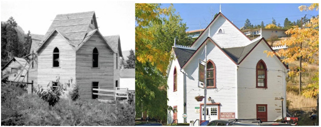
A unique Okanagan Valley building is the eight-sided Baptist Church in Peachland. It is located at 5890 Beach Avenue. It was built in 1910 and served as a church until 1964. Today it is Peachland's Museum and Tourist Information Centre. The museum features many railway artifacts and a large model railway. It must be mentioned that the museum has very knowledgeable and friendly staff.
42. Westbank Museum.
2376 Dobbin Road (Highway 97), West Kelowna
250-768-2712
The Westbank Museum started as the retirement dream of Clare and Billee Small. Clare decided that his retirement project would be to create a museum for Westbank artifacts and antiques to save as much as he could for the future. After years of frustration, delays, and disappointments, his dream was brought to fruition in October 1978 when Mr. Small received a Young Canada Works grant and permission that half an acre of his property could be donated to use as a home for the museum. The grant allowed him to hire five young people for 17 weeks to do the work required. Officiated by Premier Bill Bennett, the museum finally had an opening ceremony in July 1982. On its opening day Clare pointed out the purpose of the museum, which was to provide a heritage repository for artifacts of Westbank's early days; a facility for special interest groups, such as arts and crafts persons; a community cultural centre for the display of trade and art shows; for local collections of school history projects, and to generate community programs of historical and cultural worth. The museum resided on the Smalls' property located on Lower Glenrosa Road until 2011. During that summer, the museum moved to its new current location in downtown Westbank on Dobbin Road. The old RCMP building was transformed into a beautiful new museum. On the west side of Okanagan Lake, the Westbank Museum invites its visitors, as well as its community, to share in the goal of preserving the physical history of Westbank's achievements. Admission is by donation. They have public washrooms and a small gift shop. While in the area you may wish to walk to the Hudson Bay Company Cairn. The old cairn at Highway 97 and Old Okanagan Highway, near the Westbank Museum, commemorates the spot where fur traders and First Nations used to meet and trade.
43. Sncewips Heritage Museum.
Unit 260 at 525 Highway 97, West Kelowna
778-755-2787
The Sncewips (sen-ch-wee-ps) Heritage Museum represents the heritage of Westbank First Nation (WFN) and the stories of the syilx/Okanagan Nation as a whole. They believe in the power of their own voice to inspire, educate and transform, and are working hard to build cultural capacity and language awareness along with programming development. Admission is by donation. There are public restrooms and a gift shop.
44. Fintry Estate.
 7655 Fintry Delta Road (Fintry Provincial
Park), Kelowna
7655 Fintry Delta Road (Fintry Provincial
Park), Kelowna
250-542-4031
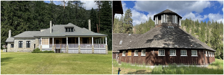
The historic buildings are within Fintry Provincial Park, amid the campsites. Named the Fintry Estate by James Cameron Dun-Waters after his home in Scotland. Dun-Waters and his first wife, Alice, built the house between 1910 and 1911. Captain James C. Dun-Waters was the incredible man who, between 1909 and 1939, made the Fintry delta a garden of Eden, a place filled with innovations far ahead of their time. Historical features throughout the park include the Manor House, the octagonal dairy barn, the packinghouse and several other farm buildings. The octagonal dairy barn was built in 1924. Tours of the Manor House and barn are available seasonally, but check the website for exact information. They have a gift shop in the Manor House and on their website as well.
45. Gellatly Nut Farm Regional Park.
2375 Whitworth Road, West Kelowna
https://www.visitwestside.com/listings/gellatly-nut-farm
250-768-2712
This family friendly and accessible park has public washrooms, picnic tables and a playground. In the fall you can purchase chestnuts, hazelnuts, walnuts, butternuts, heartnuts and buartnuts. Pioneer Jack Gellatly and his brother David started experimenting with nut cultivation, aiming for high-quality nuts and resilient trees. The Gellatlys were world-renowned nut breeders. In 2005, the farm transitioned into a regional park. There are Interpretive signs and it is wheel chair accessible.
46. Central School. This building is currently in use as a school, so please view site from the street.
1825 Richter Street, Kelowna
Built in 1913 due to the rapid growth of the city in pre-World War I and overcrowding in the last school built in 1910. Designed by architect George E. Nobles. It has classical features of the Neoclassical and Georgian Revivals, set within the formality of Beaux-Arts planning. The cost of the two-storey brick building and its furnishings was a high $75,000. It was set on a raised earth mound on a four-acre site, with broad front steps flanked by massive columns. It had 10 classrooms and an auditorium. The washrooms were located in the back field, reached by wooden boardwalks from the building.
47. Dehart/Bennett House.
1988 Bowes Street, Kelowna
http://www.okheritagesociety.com
250-861-7188
The Dehart/Bennett House was started in 1912 in the Tudor Revival style by F.R.E. DeHart, a land developer and fruit industry businessman. When the house was finished in 1914 it was called Brookside Manor. DeHart came from Ontario in 1903 and was mayor of Kelowna in 1909. In 1935 it was sold to W.A.C. Bennett, premier of B.C. from 1952-1972. It was donated by the Bennett family to the Central Okanagan Heritage Society in 2024. Access to the site is by appointment only at this time.
48. Father Pandosy Mission.
3685 Benvoulin Road, Kelowna
250-860-8369
The Father Pandosy Mission has a historical significance to the area as it is Kelowna's first European settlement, school church, and large-scale agricultural and ranching operation. All of these helped to shape the development of Kelowna. As well, it is home to various pioneer buildings and artifacts that have been moved to the site for safekeeping. The original buildings erected on the Mission site and still present are the chapel, the root house, the Brothers' house and the barn. Buildings moved to the site and of pioneer nature are the Christien house, the McDougall house, the blacksmith shop and the caretaker's quarters. The grounds are open to the public from dawn to dusk seasonally and a donation of $2 per person is suggested for admission.
49. McEachern Tobacco Barn. View from the street only.
3139 Benvoulin Road, Kelowna
The barn is a single-storey, wood-sided, structure built around 1912-13 as a large-scale farm building. It is the last of eight largely unaltered tobacco barns in the Benvoulin area of Kelowna. It is a most important reminder of an industry which, although ultimately unsuccessful, more than once looked to become the primary crop in the Kelowna area. It is characteristic of the design of tobacco-curing barns, and is associated with some families who farmed in this area.
50. St. Mary's Anglican Church
2710 East Kelowna Road, Kelowna
https://www.stmaryseastkelowna.ca
250-764-2718
St. Mary's Anglican Church is part of the East Kelowna community core, which also includes a store, community hall and pub. Constructed in 1938 by the orchardists of East Kelowna. East Kelowna was a long way from Kelowna and people were looking for a worship space closer to home. The building is a one-storey, stucco and single-clad rural church, designed in a traditional Gothic Revival style. The church is a valuable example of the growth of this rural area, and the generous community spirit of its residents. It was built by volunteer labour, under the direction of Hector Maranda (1879-1967), a prominent local contractor. It also represents the importance of local churches to small rural settlements and the central role they played in community life.
51. Train Station.
1177 Ellis Street, Kelowna
https://thetrainstationpub.com/
778-484-5558
Currently a pub, it was built in 1926 and was one of the first CN train stations in B.C. It was a key link to the national and B.C. transportation networks and was a major economic boost for Kelowna industries. It shifted industry from the waterfront to the north end. It was built with fieldstone walls, stucco and brick trim. Passenger service ended in 1967, but it was used for freight and express service until 2013 when CN ceased service.
52. Okanagan Military Museum.
1424 Ellis Street, Kelowna
http://okanaganmilitarymuseum.ca
250-763-9292
The Okanagan Military Museum is devoted to the preservation and greater awareness of Okanagan military heritage, and reveals how locals contributed to events on the world stage. A visit to the museum fosters a greater connection to the Okanagan men and women who served. The museum is home to one of the best firearms collections in Canada. It hosts a significant collection of uniforms, insignia, badges, and equipment, including artifacts from the Boer War, the First World War and the Second World War, the Korean War, the Cold War, and contemporary military operations. The museum is also home to the Vince Bezeau Military Archives and Library and is open to researchers. It has a modest admission fee, and public washrooms. Check the website for current hours.
53. Knowles House.
865 Bernard Avenue, Kelowna
https://www.kelowna.ca/our-community/arts-culture-heritage/heritage/heritage-register/knowles-house
Built in 1907. This is an example of a modest house built during Kelowna's first wave of development, and one of the few surviving cottages in the inner city. It is associated with James Bacon Knowles, the first Kelowna jeweller and civic leader, and Harry Blakeborough, the city engineer from 1921 to 1948. In 2000 Kelowna City Council approved a plan that included the conserved house within in a small park, named after James Knowles, and located at the corner of Bernard Avenue and Ethel Street.
54. Lake Country Museum and Archives.
11255 Okanagan Centre Road West, Lake Country
https://lakecountrymuseum.com/
250-766-0111
Since its inception in 1985, the Lake Country Museum and Archives has been active in collecting, preserving and presenting to the public artifacts, manuscripts and photographs documenting the history of Lake Country. The museum is within Okanagan Centre Park which has a playground, a picnic area and public washrooms. There is a walking trail that goes along the lake as well. The museum has a small gift shop. Open year round with extended hours from May to September. Check the website or call for up to date information.
55. Vernon Community Music School. Please view from the street, as this is an active music school.
1705 32nd Avenue, Vernon
https://www.vernoncommunitymusicschool.com
250-545-4977
The Vernon Community Music School is located in a heritage building known as the Smith House. It is a Dutch Colonial Revival villa built in 1908 by Samuel Cameron Smith. A large frame structure, the house is side-gabled with a gambrel roof with wide over-hanging eaves decorated with modillions. A two-storey portico with Tuscan pillars and matching semi-circular porches on either side dominates the front façade. Smith was the largest Vernon employer of his time. Smith owned sawmills, lumberyards and a sash-and-door factory. The Music School was established in 1975 as a non-profit, registered charity.
56. St. James Catholic Church.
2607 27th Street, Vernon
https://www.rcdk.org/st-james-catholic-church-1
250-542-1276
St. James Catholic Church is a landmark on Vernon's East Hill, embodying Gothic Revival architecture and more than a century of Catholic heritage in Vernon. Built between 1908 and 1910 for $14,000, its 100-foot high, elegant steeple and rusticated concrete blocks symbolize permanence and purpose. Designed by architect James Barnet, its features include a buttressed central tower, lancet arches and a nave with 30-foot concrete arches. Donated by rancher Cornelius O'Keefe, the site replaced a smaller wooden church, funded by local pioneers who rebuilt the structure after defects were discovered. The church has fostered community through organizations like the Sisters of St. Ann and the Catholic Women's League, with Monsignor John Miles leaving a lasting legacy of education and outreach through the founding of nearby St. James School.
57. Park School (now the Okanagan Science Centre).
2704 30th Street, Vernon
250-545-3644
Park School, built in 1893 for $5,000, was Vernon's third elementary school and the city's first brick school, symbolizing the community's growth and commitment to education. Designed by T. E. Crowell, the building is considered an "architectural masterpiece in brick." Over time, the school expanded from its original four-room structure, and a new high school, later named Clarence Fulton Secondary, was built nearby (and later demolished). Park School's restoration as the Okanagan Science Centre along with its heritage designation underscores its lasting value.
58. Vernon Courthouse.
3001 27th Street, Vernon
https://courtsofbc.ca/court-locations/vernon
250-549-5422
Construction of the Vernon Courthouse began in 1911, and its imposing size is testament to the fact that the building was originally intended to house not only courtrooms but also offices for a variety of provincial government departments. A key figure in the development of the building was Price Ellison, the MLA for Vernon and also the Minister of Finance and Agriculture in Premier Richard McBride's Conservative government. The building was designed by Vancouver architect Thomas Hooper in the Classical Revival style. It was constructed of reinforced concrete with a granite façade, and it required a total of 100 rail carloads of granite, four million bricks, 3,000 yards of gravel, 12 carloads of cement, one carload of reinforced steel, and 4,000 feet of pipe and conduit to complete. The granite was obtained from the Inkster Quarry on Okanagan Lake, south of Okanagan Landing. A combination of local and Italian marble was used to decorate the interior which is also notable for its ornate woodwork.
59. Vernon Canadian Pacific Railway Station.
3101 29th Street, Vernon
https://www.historicplaces.ca/en/rep-reg/place-lieu.aspx?id=17106&pid=0
The Vernon Canadian Pacific Railway Station was completed in 1911 by the prolific local builder T. E. Crowell. Built of red brick with a fieldstone base and decorated with locally-sourced granite lintels and sills, a short tower or turret, and a half-timbered dormer, the station shares many architectural elements with contemporary CPR stations such as the one at Banff (1910), and its "Swiss" or "Alpine" style was specifically designed to promote both tourism and settlement. Owing to its proximity to the Vernon Army Camp, the station served as an important embarkation point for troops during the First and Second World Wars. It continued to offer passenger services into the 1960s and, after the freight office closed in the early 1970s, it has been occupied by a number of commercial businesses and offices. The Vernon CPR Station was listed on the Canadian Register of Historic Places in 2010.
60. Ecole Beairsto Elementary. Not open to the public. Please view from the street only.
3302 27th Street, Vernon
250-542-1388
Now British Columbia's largest single-track French immersion elementary school, Ecole Beairsto was built in 1909 by the prominent Vernon contractor T. E. Crowell. The central or original portion of the school is notable for its eclectic design which includes a mansardic roof, Georgian elements, a Palladian dormer window, and a large octagonal cupola that functions as a skylight for the school library. Originally known as Vernon's "Central School," the building was renamed in 1961 following the retirement of its long-time principal Harold Beairsto.
61. Caetani Centre.
3401 Pleasant Valley Road, Vernon
250-275-1525
Caetani Centre is located in a large, Late Victorian Vernacular Revival style residence that was built in 1895 for Samuel Sommerville, a Vernon alderman and city tax collector. In 1921, the house was purchased by Duke Leone Caetani di Sermoneta who was alarmed by the rise of fascism in his native Italy, and for the next 70 years it was home to his daughter Sveva. The Caetani House is now a museum that contains many of Sveva's effects, as well as her family's, including fashion by Chanel and Vionnet, and furniture designed and sometimes built by her. A painter who was denied her art for almost 25 years, Sveva was able to become an artist and teacher who used a drybrush watercolour technique to make luminous paintings like her Recapitulation series. Open seasonally. Tours are available. Check the website for current information.
62. Vernon Cadet Camp-Museum at the Vernon Military Camp.
4317 Crystal Drive, Vernon
https://www.vernoncadetmuseum.com
250-503-1125
The Vernon Military Camp was established in 1912 on Mission Hill near Vernon after the formation of the 30th B.C. Horse regiment. Initially it served as a summer training ground for cavalry and infantry militia. Used during both World Wars, it became a key site for training soldiers, including disembarkation drills for D-Day during the Second World War. After the war, it transitioned to training Canadian army cadets, instilling citizenship and leadership in thousands of youths, some of whom later joined the Canadian Forces. The camp also supported Operation Peregrine during B.C.'s 2003 wildfire crisis. While the site remains active Department of Nation Defence (DND) land, the Vernon Cadet Camp Museum operates on scheduled hours during the summer and offers tours by appointment the remainder of the year.
63. Stationhouse Museum.
7813 Okanagan Landing Road, Vernon
https://okanaganlanding.com/about/history
250-542-2500
Okanagan Landing, along the shores of Lake Okanagan near Vernon, has a rich history rooted in its Indigenous heritage and its role as a transportation hub for the Okanagan Valley. Sternwheelers like the Aberdeen, Okanagan, Sicamous, and tugboat Naramata were built at the Landing, a centre of commerce and CPR activity over a century ago, with the stationhouse serving as the main boarding facility. After railway services ended in 1936, the stationhouse passed into private ownership until its donation in 1982 by Wes and Kay Whitehead to the Okanagan Landing & District Community Association. Now a museum, it preserves memorabilia, photos and a detailed 1914 scale model of the landing.
64. BX Ranch. Not open to the public, please view from the road.
845 BX Road, Vernon
https://vernonmuseum.ca/the-bx-ranch-house
The Barnard's Express stagecoach line (known to all as the "BX") ran from Yale at the foot of the Fraser Canyon to Barkerville, beginning in 1864. In 1873, Francis J. Barnard filed a pre-emption for 320 acres on the east side of Swan Lake. The BX Ranch became the breeding centre for the stagecoach horses, described as "derived from Morgan and thoroughbred crosses on Spanish foundation stock." Barnard's son, Francis Stillman Barnard, enlarged the ranch by purchasing more land until, in the 1890s, it comprised 1,560 acres (1036 hectares). The ranch changed hands several times until 2016, when a large portion of the land was sold to the North Okanagan Regional District.
65. Grey Canal Trail System.
Multiple locations, Vernon
https://www.ribbonsofgreen.ca/grey-canal-trail
The Grey Canal Trail System follows the course of the main channel of British Columbia's largest irrigation network. Constructed between 1906 and 1914 and designed to irrigate over 20,000 acres, the 50 km-long main canal winds its way west from Lavington through the hills above the Coldstream Valley, north around the city of Vernon and Swan Lake, and south to the orchards of Bella Vista above Okanagan Lake. Although the canal ceased operation in 1971, remnants of the old network such as siphons, flumes and concrete water distribution boxes are still visible along portions of the trail, and most of the trail sections offer panoramic views of the communities of Coldstream, Vernon and of the surrounding countryside. Bird watchers, botanists, and other natural history enthusiasts will also find much of interest along the trail system as it traverses some of the best-preserved native grasslands in the North Okanagan region. Seven sections of the trail system have been completed (approximately 20 km in total). A few sections have been rated as moderate to difficult owing to steep climbs and even some scrambling, but most are rated as easy and consist of flat, mainly level surfaces that are suitable for walking, biking and various winter activities. The Ribbons of Green Trail Society in conjunction with the Regional District of the North Okanagan hopes to complete the system by adding additional sections around the north and south sides of Swan Lake.
66. Luc Girouard Cabin/Nin-ti-moose-chin.
Northwest of 30th Avenue, 3001 35th Street, Vernon
https://www.historicplaces.ca/en/rep-reg/place-lieu.aspx?id=17102
Luc Girouard was born in 1821 in Grantley, Nicolet County, Quebec. He came to the Okanagan in the 1860s. On November 1, 1867, he pre-empted 160 acres and became the first white person to live on the site of today's Vernon. He planted the first apple orchard in the North Okanagan and was the first postmaster for the Priests' Valley Post Office in 1884. Girouard built his cabin on Swan Lake Creek, next to the creek crossing, nin-tl-moose-chin (nϯƏϯtpmuscin) "jumping over place," that had been used by the Syilx People for centuries. The cabin is now within a small park.
67. Coldstream Lake House (Mackie Lake House).
7804 Kidston Road, Coldstream
250-545-1019
The Lake House was designed for the family of Rupert Charles Buchanan of Montreal who moved into the house in 1910. The Buchanans moved from Coldstream to Vancouver in 1923 and the house was purchased by the Layton family two years later. The Laytons sold to the Mackies: Austin, Hugh and his wife, Grace, in 1940. The Layton's daughter, Elizabeth, went to England and became Winston Churchill's secretary through the Second World War. The Mackies had founded the Vernon Preparatory School in 1913 and ran it until the late 1940s, when they retired to the house. Hugh and Grace had five sons, all but one of whom died young. That left Patrick "Paddy" Mackie who inherited the house and lived in it until his death in 1999. It was Paddy who set up the Mackie Lake House Foundation that now operates the site. The house has remained virtually unchanged since 1910. Guided tours are available. Check their website for more information.
68. Coldstream Ranch. Not open to the public, please view from the road.
9015 Highway 6, Coldstream
http://www.coldstreamranch.ca/coldstreamranch/Welcome.html
The Coldstream Ranch was established in 1863 by Captain Charles Fredrick Houghton, with a 1,450-acre Crimean War grant application. In 1882, Houghton traded his interest in the property to fellow British Army officers, Charles and Forbes Vernon. Forbes Vernon purchased additional surrounding lands and sold the 13,262-acre property to Lady and Lord Aberdeen, the future Governor General of Canada, in 1891. The Aberdeens developed the property for settlers by subdividing the area, from the ranch headquarters to Kalamalka Lake, into smaller acreages, providing water for irrigation and planting fruit trees. The ranch was sold to Sir James Buchanan, Lord Woolavington, in 1920. The Buchanan family continued to own the property until 1994. During this period ranch managers directed the production of numerous crops and a range of livestock with apple production and beef cattle being the most prominent. Some peripheral lots were sold in the 1970s including 2,274 acres which became Kalamalka Lake Provincial Park. The core area of the ranch contains numerous historic structures dating from ca. 1880 to 1919. Today, the ranch is an intensively operated beef cattle enterprise with some 10,700 acres of land.
69. O'Keefe Ranch.
9380 Highway 97, Spallumcheen
250-542-7868
O'Keefe Ranch was founded in 1867 by Cornelius O'Keefe. His family lived on site for 110 years before it was opened as a historic ranch, meaning it still houses one of the most complete collections of one family's belongings (from the Victorian and Edwardian eras) in all of the province. Today O'Keefe Ranch is operated by a non-profit society and is a registered charity. Visit during the open season from May to October. Stroll along the boardwalk, visit the original buildings (set up as they were more than 100 years ago!), visit the Greenhow Museum, and go say hello to the many farm animals. There are public washrooms, food service and a campground. Check the website for more details.
70. Okanagan Rail Trail.
Trailhead is on WestKal Road, Coldstream
The Okanagan Rail Trail, spanning 50 km from Coldstream to Kelowna, transforms a former Canadian National (CN) rail line that operated between 1925 and 2013 into a scenic multi-use pathway. With a gentle 1.3% grade, it links three picturesque lakes, offering stunning views and serving as a vital walking and biking route for the communities it passes through. With financial support from the provincial government, local and municipal governments purchased the discontinued CN rail corridor, creating a unique opportunity to establish a lasting legacy for local communities. The North Okanagan and Lake Country sections feature a compact crushed aggregate surface, while the developed section in Kelowna is paved. Vernon connects to the trail via a multi-use path that begins in the city centre, runs through Polson Park, and follows Kalamalka Lake Road, leading to the trailhead on College Way in Coldstream.
71. Silver Star Provincial Park.
22 km Northeast of Vernon
https://bcparks.ca/silver-star-park
Silver Star Mountain was popular with Indigenous peoples for berry picking and for camping and hunting during the hot summer months. In the 1890s mineral claims were registered on the mountain (Prince of Wales, Aberdeen, Silver Star, etc.) and extensive mining exploration and operation took place. In 1914 a forestry lookout was built on the mountaintop to take advantage of commanding views. In the 1920s, the people of Vernon began to access the mountain for skiing and berry picking, and a road was constructed to within a short distance of the summit. The area was designated a provincial park in 1940 and, in 1957, approval was granted to Sliver Star Sports to develop a ski resort. The mountain is a popular destination for skiing and snowmobiling in the winter and hiking and mountain-biking in the summer.
72. Wilsey Dam and Generating Station.
1642 Lumby-Mable Lake Road, Lumby
https://www.bchydro.com/energy-in-bc/projects/wilsey-fish-passage-project.html
The West Canadian Hydro Electric Corporation (which later became BC Hydro) constructed the Wilsey Dam and generating station at Shuswap Falls in 1929. The concrete dam was built at the site of the original 21-metre-high Shuswap Falls while the spillway channel was blasted through solid rock immediately to the north. In 1942, a second dam was constructed at the outlet of Sugar Lake to create storage and increase generating potential. This new dam allowed for another generating unit at Shuswap Falls, which resulted in a total of 6.0 MW of capacity. From 1929 to 1951, the Shuswap Falls facility provided most of the electric power for the North Okanagan region. BC Hydro recently announced that it would like to decommission the historic facility as part of a salmon-enhancement project.
73. Lumby and District Museum.
1785 Glencaird Street, Lumby
https://www.rdno.ca/parks-rec-culture/parks/lumby-district-museum
250-547-9524
Lumby & District Museum is a registered not-for-profit society with a mission to collect, protect and exhibit artifacts and materials that are significant to the Village of Lumby and surrounding rural areas. It is open seasonally from June to September, Wednesday to Saturday.
74. Armstrong Elementary School. This is an operating school, so please observe from the street only.
3010 Pleasant Valley Road, Armstrong
Armstrong Elementary School (AES) in Armstrong, British Columbia has a history that dates back to 1921. It was the first consolidated school in the province and the first to have a school bus system. The school opened on September 8, 1921. It had a boys' entrance and a girls' entrance and 10 classrooms. Over 100 years later students still attend classes there.
75. Armstrong Spallumcheen Museum and Art Gallery.
3415 Pleasant Valley Road, Armstrong
http://www.armstrongspallmuseumart.com
250-546-8318
The Armstrong Spallumcheen Museum and Art Gallery is located in historic downtown Armstrong. The first building on this site was moved from Lansdowne circa 1892 when most of that community relocated to Armstrong. In 1905 F.A. Clayton bought the existing blacksmith business. Over time he expanded the building. The business was later operated by his sons and gradually changed into a machine shop. It has also served as a storage facility, automobile garage and gas station. Since becoming a museum, the facility has been upgraded many times. The renovations in 2011 included fresh paint, new signage, a timber frame entrance and a colonnade. It now has a brand new, but still historic, look for a favourite old building. It is open from May 1 to December 30. Please check the website for current information.
76. Interior Provincial Exhibition Grounds.
Park Drive, Armstrong
250-546-9406
Well over 100 years ago land was donated to be used for what became the Interior Provincial Exhibition. The first barns to house livestock were built in 1910 and an additional building was constructed in 1916. The barns burned down in 1925, so between 1927 - 1929 sheep, swine, poultry and cattle barns were built. These barns were located just west of the new grandstands by the Centennial Hall. The IPE Fair is held every year during the Labour Day weekend, and the grounds are used for many different activities through the year.
 77. Lansdowne Cemetery.
McLeery Road, Spallumcheen
GPS 50.47306, -119.15692
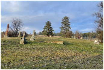
The Lansdowne Cemetery is located in the Municipality of Spallumcheen which has served numerous settlements in the North Okanagan for over 100 years. The first interment was in 1882 and the last in 1999. The village of Lansdowne was located on the bench above the valley where Armstrong is now located. With the coming of the railway in 1892, the route selected for the Shuswap and Okanagan railway bypassed the village. As a consequence, the village of Lansdowne disappeared. Many of the buildings, including the Anglican Church, were eventually moved to the community of Armstrong. Prior to 1913 when the Armstrong Cemetery opened, the citizens of Armstrong were buried at Lansdowne. The land used for the Lansdowne Cemetery was donated by Herman Wichers. The Lansdowne cemetery continued to be used into the 1940s and still allows cremation remains to be interred. Famous settlers are buried there: Alexander and Batha Fortune Catherine O'Hare Schubert and Augustus Schubert. These graves may be found at the north end of the grounds on the right-hand side.
78. Enderby City Hall and Enderby Museum.
619 Cliff Avenue, Enderby
250-838-7170
The Enderby City Hall and Enderby Museum are on the corner of Cliff Avenue and Highway 97. The city hall was built with Enderby bricks just after incorporation in 1905. It was added on to in the late 1980s. City council applied for an Expo 86 Legacy grant for the addition. The grant stipulated a cultural component so the Okanagan Regional Library and the Enderby Museum were invited to occupy the bottom spaces. At the beginning of the twenty-first century, the library moved to a larger location and the museum moved into the former library space. The museum is open year-round.
79. Enderby Drill Hall.
208 George Street (Highway 97A), Enderby
https://www.cityofenderby.com/city-hall/parks-and-recreation/drill-hall/
250-838-7230
The Enderby Drill Hall on the west side of Highway 97 was built of Enderby bricks in 1914 just in time for the First World War. It has been modernized in the interior with newer washrooms and a small kitchen. It is exactly the same as the hall in Armstrong but that hall has been added onto and made into a theatre. The federal government turned the hall over to the City of Enderby in the early 1950s. Today the hall is rented out for private events. It has a capacity of 200. It is used for a variety of functions ranging from recreation programming to dances.
80. Jim Watt Heritage Riverwalk.
Enderby
GPS 50.54919085, -119.1357963
https://shuswaptrails.com/trails/system/70/Jim-Watt-Heritage-River-Walk
The Jim Watt Heritage Riverwalk goes from Belvedere Park in Enderby to Riverside Park. It is a 2.7 km out-and-back trail, and takes about 45 minutes to complete. The trail is great for biking, running and walking. It was created in the late 1990s and has historical reference signs indicating the significance of the location in Enderby's past. These signs were designed by the Enderby and District Heritage Commission. You can also enjoy a view of the river as you walk along. Watch for turtles and beavers near the island. Parking is available at either end of the walkway, and washrooms are available in the Travel Info Centre in Belvedere.
81. Sawmill Manager's House. Private home, please view from the street.
Cliff Avenue and Sicamous Street, Enderby
The sawmill manager's house is on the corner of Cliff Avenue and Sicamous Street, one block west of Highway 97. It can be clearly viewed from Sicamous Street. The house next to it was the assistant manager's home and just past that was the accountant's house. All three have brass Enderby Heritage Commission plaques on the sidewalk. They were built by the A.R. Rogers Lumber Company at the beginning of the 20th century when the mill produced more lumber than all the other mills in the Okanagan Valley.
82. St. George's Anglican Church.
Knight Street near George Street, Enderby
St. George's Anglican Church is one block east of Highway 97 on Knight Street. It is the oldest Anglican Church in the Okanagan Valley still on its original foundations. The Anglican Church at Lansdowne is older but it was moved shortly after St. Georges was built to Armstrong, plus it has been added onto. Services continue once a week throughout the year.
83. Kingfisher Environmental Interpreter Centre.
2550 Mabel Lake Road, Enderby
https://www.kingfishercentre.org/
250-838-0004
Kingfisher Environmental Interpreter Centre is 30 minutes east of Enderby on the south side of Mabel Lake Road where Cooke Creek enters the Shuswap River. The Kingfisher Environmental Interpreter Centre was established over three decades ago in response to the near extinction of salmon stocks in the Shuswap River. It originally began as a salmon enhancement project which entailed capturing returning salmon, taking eggs, raising the babies and releasing them in the spring. It has moved from hatchery to environmental interpretation complete with trails and a replica native pit house. If the gate is open, go in. There are washrooms available.
84. Falkland Museum Heritage Park Info Centre.
56576 Highway 97, Falkland
https://www.falklandmuseum.ca/home
250-379-2535
The Falkland Heritage Park and Museum is located in downtown Falkland, B.C. - right on Highway 97. The park is located on two acres that was part of the original Falkland Gypsum Mine. There is a wonderful display of historic memorabilia that can be enjoyed by the entire family. Make sure that you stop here for a visit to a place back in time. Call before visiting to confirm hours.
 85. Mara Community
Church.
85. Mara Community
Church.
396 Riverside Road, Mara
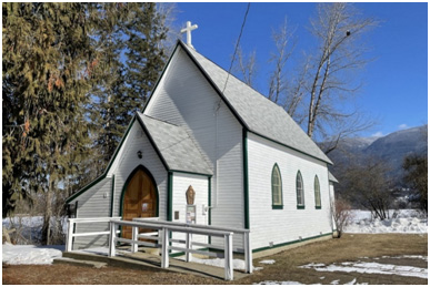
Mara Community Church is 30 minutes north of Enderby on Riverside Road in Mara. Take Highway 97 north through Grindrod to Mara. Turn left onto Riverside Road just past the Mara Cemetery, travel about five minutes to a very small but lovely little church. Originally it was an Anglican Church built in 1912 but over the years it has evolved into a non-denominational church. Sunday services still occur there and are shared by various denominations through the year. If you follow Riverside Road a little further down, you will see the bridge which crosses the Shuswap River. As you approach the bridge you will see the community hall (built in 1911) on the west side of the river.
86. Canoe Victory Hall. Please observe from the road. The site is now private and houses a daycare.
7210 51st Street, Canoe
Constructed in 1919, Victory Hall is valued for its historic, cultural and social significance within the community, particularly for its role in commemorating the 'Empire's victory in World War I' and for its historic use as a place of public worship and continued use for social gatherings and other events.
87. Canoe United Church.
6861 50th Street NE, Canoe
Canoe United Church was founded at the time of church union in 1925 and is part of Kamloops-Okanagan Presbytery. Prior to church union, Methodist services began in Canoe as early as 1888 as members of an interdenominational church gathered in people's homes. Rev. Calvert was the first minister to serve the community. He frequently travelled from Revelstoke by horse and walked when weather was poor. When the Canoe School was built in 1908, the community congregation faithfully met there. When the community hall was built in 1919, services relocated to "Victory Hall." Rogert Kirk donated a lot to build the church in 1921. Members of the Methodist Church financed the structure. Contractor W.H. Ireland completed the building for $1,593.
 88. R.J. Haney Heritage
Village, Museum and Archive.
88. R.J. Haney Heritage
Village, Museum and Archive.
751 Highway 97B, Salmon Arm
250-832-5243
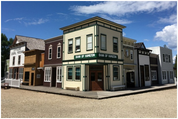
On the east side of Salmon Arm at 751 Highway 97 B, R.J. Haney Heritage Village & Museum spans 40 picturesque acres of the Shuswap's most charming farmland. The site features 24 buildings, a mix of replicas and originals, and over 30 exhibits, including the iconic 1910 Haney House. There are public washrooms, a gift shop, a 2.3 km walking trail through the woods and the "Sprig of Heather" restaurant where you can get a quick snack or full meals. Additionally, there is a children's museum, outdoor discovery area and beautiful gardens. The site is open from May to September. Check their website for hours and special events.
89. Salmar Theatre.
360 Alexander Street, Salmon Arm
250-832-2263
After the Second World War a group of dedicated citizens wanted to create a living memorial for soldiers who did not return from the war. They came upon the idea of building a theatre. Funds generated from the theatre paid for the building of the Memorial Arena. The Salmar Theatre is a two-storey, Art Deco-style building with a half-culvert proscenium located mid-block on Alexander Street in downtown Salmon Arm. The building was constructed using a Quonset design developed during the war and later used extensively in Canada and the United States for theatre purposes. The theatre is a busy venue featuring off-release movies, concerts, and Film Society offerings. Check their website for current information.
90. Three Sisters.
31 Hudson Avenue, NE, Salmon Arm
Three brick buildings can be seen from the corner of Hudson Avenue and Shuswap Street North: the art gallery (previously the post office), the old courthouse and the municipal hall. Each building was constructed of bricks thought to be from the Enderby Brickyard, and were built by local contractor William Reader. The post office was built in 1937 and was designed by Thomas W. Fuller. The courthouse was built in 1931. The municipal hall was built in 1928. Each building has an Arts and Crafts influence.
91. Mount Ida Cemetery.
2290 Foothill Road SW, Salmon Arm
Mt. Ida Cemetery dates from 1894. It is the resting place of most of the early settler families in the area. It has a large number of veterans' graves.
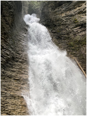 92. Herald Park.
4861 Sunnybrae-Canoe Point Road, Tappen
Herald Park is situated on traditional Secwepemc territory along the western shore of Shuswap Lake. In 1906 Dr. Dundas and Edith Herald with their children Jesse and James purchased the property from John Reinecker. A son Arthur was born later. They lived on the property they called Bonny Bray far from any neighbours. They had to row a boat across the lake to buy provisions, so they were very self sufficient. The children were schooled at home, and the family led a very isolated life. The land was donated to the government to be used as a provincial park. Daughter Jesse remained on a small part of the land until her death in 1994. Within the park, you can find a trail leading to Margaret Falls on the Reinecker Creek. Herald Park has a large campsite; boat launch and day-use area.
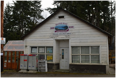 93. Blind Bay.
2371 Blind Bay Road, Blind Bay
Two families, the Reedmans and the Barnards landed in Notch Hill in 1905 and were looking for a place to homestead. Reedman was headed for Saskatchewan, but Barnard persuaded him to take a look at the Shuswap. The two men went trekking through the trails and came out at Blind Bay. They decided that they had found their home. The Reedmans were an important family, helping the other families and establishing a ferry to service the North Shuswap. In the early times, it was said that the captains couldn't see Blind Bay until they were well passed it because of the angle at which the bay joins Shuswap Lake. Reedman Road Community Park is the site of the original ferry landing. There is an interpretive sign on John Reedman. From here you have a good view of Copper Island, the only island in Shuswap Lake. Called Cemete'tkwe in the traditional Secwepemctsin language, the island was important to the Indigenous People and there are many legends told about it
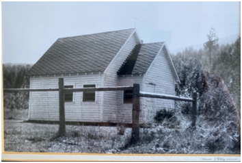 94. Eagle Bay Church.
4802 Eagle Bay Road, Sorrento
https://www.eaglebaybc.ca/community-services
250-675-5038
The Eagle Bay Heritage Community Church has been an important part of the community since it was originally built in 1945. Local residents Signe and Robert Davidsen donated a piece of land for the cemetery and, in addition, made a request for a small church to be built alongside. In 1946, a pragmatic group of local citizens cleared the land for a cemetery and constructed a small church. It was decided from the onset that the church would be nondenominational. Since that time the little church has undergone a number of facelifts and has hosted many services, weddings, baptisms and funerals. The adjacent cemetery is the final resting place for many Eagle Bay pioneer families and a walk through the grounds will result in recognition of community names like Galligan, Turgeon and Whitehead.
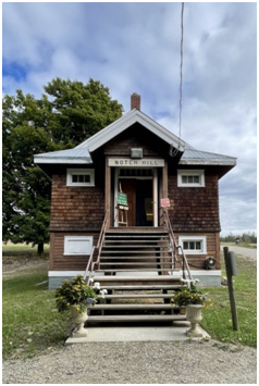 95. Notch Hill.
1639 Notch Hill Road, Notch Hill
https://www.southshuswapchamber.com/directory/notch-hill-town-hall-association/
250-835-4721
Located near Sorrento, B.C., is the hamlet of Notch Hill, where three heritage buildings stand to help tell the history of the historic rail side community: the community hall, the school and the church. The small community is where one of the oldest halls in the Shuswap is still standing tall a century later, thanks to the hard work done by members of the Notch Hill Town Hall Association. The Notch Hill Town Hall was built in 1910 and it was on land that was donated by the farmers. Notch Hill was really well-known as a railway town back in the day; everything arrived by train. There was no Trans-Canada Highway and it was all done by the steam engine. The site has parking and a covered viewing platform to watch the trains go by. In addition, there is signage that explains the unique "Notch Hill Incline." Picnic tables are provided for a nice place to stop and have lunch. "Tea" is served in the schoolhouse most summer days, and the site is used for several events. Call or check the website for up-to-date information.
96. Notch Hill Cemetery.
1729 Hilltop Road, Notch Hill
The property on which the Notch Hill Cemetery is located was part of pioneer homesteader, John McIntyre's ¼ section. Mr. McIntyre donated approximately an acre and half of his land for use as a cemetery in the 1890s. The first recorded burial is baby Morris Burton Johnson in 1899. Historical burials in the cemetery include the Scarlet Fever epidemic that struck the area in January of 1903 resulting in the deaths of several children. On July 20, 1903, there was an accident at Kault when the Columbia River Logging Co. wooden trestle collapsed. Two men died in this accident. They each have a tall, marble upright headstone, side by side. One interesting grave in this cemetery holds the remains of five men who died on June 22, 1909. These men, who were hitching a ride in a boxcar, died when a flange broke and the box car overturned, down an embankment. They were brought to Notch Hill Cemetery by horse and buggy and buried. Commemorative signage was erected in the cemetery to honour these men. There is a veterans' section as well.
97. Sorrento Centre. Now a Retreat and Conference Centre. The site is used extensively for private events, so please call before visiting.
1159 Passchendaele Road, Sorrento
https://sorrentocentre.ca/a-history-of-the-sorrento-retreat-and-conference-centre
250-675-2421
Early in the 1900s, James Reid Kinghorn travelled from Montreal and settled with his family on the shores of Shuswap Lake to build an estate and working commercial orchard. The breathtaking view of Copper Island in Shuswap Lake reminded him of his honeymoon sighting of the Isle of Capri which he saw from Sorrento, Italy. When Mr. Kinghorn first looked out over the orchards, Shuswap Lake and Copper Island, he was reminded of Italy, the Bay of Naples and the Isle of Capri. "We shall call this town Sorrento." The town was so named in 1912. A magnificent house was built for Mr. Kinghorn's bride, Winifred, out of Douglas fir, which they named Spes Bona. Translated from Latin, it means 'Good Hope.' Sadly, the original home burned down and in 1927 the second Spes Bona was built in its place and stands today.
98. Squilax Bridge.
Highway 1 and Squilax-Anglemont Road, Squilax
GPS 50.870223, -119.583384
The first Squilax Bridge was opened in 1930 and made access to the North Shuswap much easier, vastly changing life on the Shuswap. The cement pillars from the original bridge can still be seen. Before the bridge there was just a cable ferry to cross Little River. The new bridge was completed in 1990.
99. Scotch Creek - Sorrento Ferry.
3836 Zinck Road, Scotch Creek
GPS 50.89882, -119.45838
In Scotch Creek head to the Scotch Creek Wharf Road Community Park. There are a few remains of the old wharf. From 1914 to 1956 a ferry ran between Scotch Creek and Sorrento. Ferries such as the Rowena, G.B. Wright, and Rolf Bruhn ran the water of Shuswap Lake. Captain Disney Poole, a First World War veteran served as ferry captain from 1919 to 1952.
100. Celista Centre.
5448 Squilax-Anglemont Road, Celista
GPS 50.94626, -119.33974
Celista was originally called Fowler's Landing after first settler, Harry Fowler. He organized the building of the first school in 1910. Here you will find the North Shuswap Community Hall, Cemetery, St. David's Church, and Pioneer Park. The community hall was completed in 1934. The school (now gone) was located here until 1950. This area has been the heart of the community for over 100 years.
101. Sicamous and District Museum and Historical Society.
466 Main Street, Sicamous
250-836-5260
Situated in the beautiful Eagle Valley, Sicamous has long been a place of gathering and community as it is located at the joining of the Shuswap and Mara Lakes, Highway 1 and 97A, and was once a major stop on the railway system. The Sicamous & District Museum & Historical Society is a non-profit society that collects, documents and preserves the history of the beautiful lake town. Inside you will find a collection of photographs, artifacts and a scale model of the C.P.R. Sicamous Hotel.